






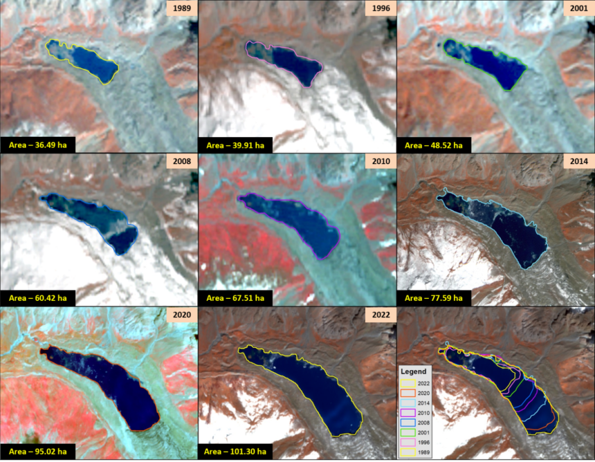
The Glacial Lake Monitoring initiative has commenced with Science & Technology teams launching satellite-based surveillance of high-altitude glacial lakes. The effort aims to strengthen observation of vulnerable water bodies, improve scientific data collection, and support early monitoring of changing conditions in mountainous regions.
Refurbished Community Facility Opens to Improve Healthcare Access
Glacial Lake Monitoring Initiative Begins with Satellite-Based Assessments
The Glacial Lake Monitoring programme has entered a new phase as Science & Technology teams initiated satellite checks on high-altitude glacial lakes. The initiative focuses on using remote sensing technology to observe glacial lakes and gather information about their changing conditions.
According to the available information, the satellite-based assessments will help experts monitor high-altitude water bodies through regular observations. Moreover, satellite technology enables scientists to collect data from remote and difficult-to-access regions without relying solely on ground surveys.
High-altitude glacial lakes require continuous observation because environmental conditions can change over time. Therefore, systematic monitoring supports scientific research and strengthens the understanding of mountain ecosystems.
The latest initiative reflects ongoing efforts to apply modern technology to environmental monitoring. Additionally, satellite observations can provide valuable information for future planning and scientific analysis.
Glacial Lake Monitoring Strengthens Scientific Observation
The Glacial Lake Monitoring programme demonstrates the growing role of satellite technology in environmental research. Remote sensing systems allow experts to observe geographical features over large areas while collecting consistent and reliable information.
Moreover, satellite imagery helps scientists monitor changes in the size, location, and surrounding conditions of glacial lakes. Consequently, researchers can compare observations over time and identify environmental trends.
Science & Technology teams regularly use advanced monitoring tools to improve the quality of environmental assessments. Furthermore, satellite-based monitoring complements field studies by providing broader geographical coverage.
The latest initiative highlights the importance of technology-driven research for understanding high-altitude ecosystems. However, the available information does not specify the number of lakes included in the monitoring programme.
Satellite Technology Supports Glacial Lake Monitoring Efforts
The Glacial Lake Monitoring initiative relies on satellite technology to improve observation of remote mountain regions. Satellites can capture detailed imagery that assists scientists in evaluating environmental conditions across difficult terrain.
Additionally, remote sensing reduces the need for frequent physical inspections in areas that may be challenging to access. This approach allows researchers to gather information efficiently while maintaining continuous monitoring.
Scientific agencies often combine satellite observations with other research methods to improve the accuracy of environmental studies. Meanwhile, regular data collection helps experts evaluate natural changes occurring in glacial regions.
The use of satellite monitoring also supports better long-term environmental documentation. Therefore, researchers can build comprehensive records that contribute to future scientific studies and policy planning.
The initiative reflects the increasing importance of technological innovation in environmental management and research.
Glacial Lake Monitoring Contributes to Environmental Research
The Glacial Lake Monitoring programme carries broader significance for environmental science and sustainable resource management. High-altitude glacial lakes form an important part of mountain ecosystems and require careful scientific observation.
Moreover, continuous monitoring helps researchers improve their understanding of environmental processes in sensitive regions. Reliable scientific data also supports informed decision-making related to ecosystem management and future research initiatives.
The involvement of Science & Technology teams demonstrates the importance of interdisciplinary collaboration in environmental studies. Similarly, the use of advanced satellite systems highlights the role of innovation in strengthening scientific capabilities.
Environmental monitoring programmes contribute to long-term knowledge by providing updated information about changing natural conditions. Consequently, regular satellite assessments remain valuable tools for scientific observation and research planning.
As the monitoring programme progresses, future official updates may provide additional details regarding observations and research findings.
Conclusion
The Glacial Lake Monitoring initiative has begun with Science & Technology teams launching satellite checks on high-altitude glacial lakes. The programme represents an important step toward improving environmental observation through modern remote sensing technology.
Furthermore, satellite-based monitoring enhances scientific research by enabling continuous observation of remote mountain regions and supporting long-term environmental assessments. The initiative also demonstrates the growing role of technology in environmental management.
Overall, the Glacial Lake Monitoring programme strengthens scientific efforts to observe high-altitude ecosystems while expanding the use of advanced monitoring tools. As research continues, future official updates are expected to provide further insights into the programme’s progress and findings.
FAQs
1. What is the Glacial Lake Monitoring initiative?
The Monitoring initiative involves satellite-based observation of high-altitude glacial lakes by Science & Technology teams.
2. Why are satellites being used for glacial lake monitoring?
Satellites help scientists monitor remote glacial lakes efficiently and collect consistent environmental data.
3. Who is carrying out the Glacial Lake Monitoring programme?
Science & Technology teams have initiated the satellite monitoring of high-altitude glacial lakes.
4. What is the purpose of the monitoring programme?
The programme aims to improve scientific observation, collect environmental data, and monitor changing conditions in glacial lake regions.
5. Will the programme include future observations?
Yes. Satellite monitoring supports continuous observation, and future official updates may provide additional findings.