






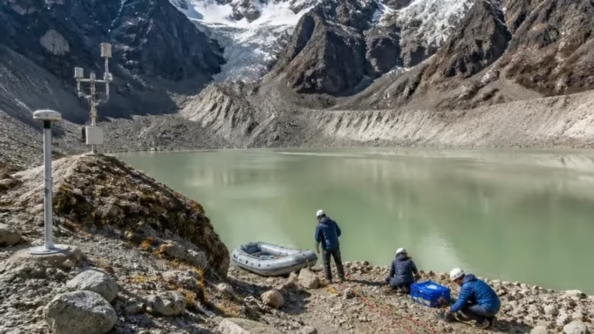
Sikkim has completed a major field-based study of nine high-risk glacial lakes to better understand and reduce the threat of Glacial Lake Outburst Floods (GLOFs) in the Eastern Himalaya. Scientists conducted the study between 2022 and 2025 and published the findings in the journal Natural Hazards in 2026.
The research examined lake depth, water volume, moraine stability and hidden seepage channels. Importantly, the team found that satellite images alone cannot fully reveal the risks surrounding vulnerable glacial lakes.
The findings could help authorities design targeted measures to protect downstream communities and infrastructure.
Read More: Meghalaya Beat Maharashtra 3-0 in National Championship
Key Facts
- Location: Sikkim, Eastern Himalaya
- Study period: 2022–2025
- Glacial lakes studied: 9 high-risk lakes
- Research published: Natural Hazards, 2026
- Largest lake studied: Khangchung Chho
- Khangchung Chho water volume: More than 125 million cubic metres
- Key concern: Glacial Lake Outburst Floods (GLOFs)
- Major finding: Ground surveys revealed risks that satellite imagery could not detect
Detailed Field Study
Scientists from the Sikkim Science and Technology Department, Sikkim University and partner institutions carried out the research.
Unlike studies that rely mainly on satellite images, this project involved extensive field investigations. Researchers examined the physical and geological conditions of the lakes and their surrounding areas.
The team conducted bathymetric surveys to measure lake depth and calculate water volume. They also used an unmanned surface vehicle to map lake beds and collect information that earlier assessments could not provide.
Hidden Risks Found Beneath Moraine Dams
Researchers also used electrical resistivity tomography to study areas beneath moraine dams.
The surveys identified potentially dangerous features, including saturated zones, buried ice and hidden seepage channels. These features can increase the vulnerability of moraine dams.
The findings also showed why lake size alone cannot determine GLOF risk. Two lakes with similar surface areas can hold very different amounts of water because their depths and basin shapes differ.
Khangchung Chho and Lachung Khangtse
Among the nine lakes, Khangchung Chho emerged as the largest and deepest. Researchers estimated that it holds more than 125 million cubic metres of water.
In contrast, Lachung Khangtse remains relatively shallow and contains less than two million cubic metres of water.
Therefore, the study highlights the need to examine individual lakes in detail rather than assess their risks only by surface area.
Important Finding at Shako Chho
Researchers made another significant discovery at Shako Chho. Subsurface surveys detected seepage channels several metres below the moraine crest.
Conventional remote-sensing methods could not identify these hidden channels. As a result, the finding demonstrates the importance of combining satellite data with ground-based investigations.
Researchers estimate that lowering Shako Chho’s water level by around 20 metres could remove approximately 11 million cubic metres of stored water.
They have proposed a solar-powered pumping system as one possible mitigation measure. However, authorities would need to assess the feasibility and safety of the proposal before implementation.
Early Warning System
The project has also strengthened monitoring at Shako Chho.
An automatic weather station now tracks weather conditions and lake-level changes. This information can help disaster-management authorities identify warning signs and respond more quickly.
Meanwhile, researchers have proposed a four-stage approach to reduce GLOF risks. The process starts with satellite screening, followed by detailed field assessments, engineering design and, finally, on-ground mitigation measures.
Importance for the Himalayas
The researchers believe this approach could help other vulnerable regions of the Hindu Kush Himalayas, including areas of Nepal and Bhutan.
They have also called for greater use of technologies such as drone-based LiDAR mapping and satellite radar deformation monitoring. These tools could help scientists study lakes that remain difficult to access because of terrain, weather or other local conditions.
The National Disaster Management Authority has identified 189 high-risk glacial lakes across the Indian Himalayan Region. Therefore, Sikkim’s field-based approach could help authorities move from general hazard identification to practical, site-specific risk reduction.
Climate Change and GLOF Risk
Climate change has increased concerns about the growth and stability of Himalayan glacial lakes.
For this reason, researchers stress the need for close cooperation between scientists, geologists, engineers and disaster-management agencies.
Detailed information about water volume, lake depth, moraine stability and seepage can help authorities develop measures suited to each lake.
Ultimately, the study aims to reduce disaster risks and protect downstream communities, infrastructure and livelihoods across the Himalayan region.
Q&A
What did Sikkim study?
Scientists studied nine high-risk glacial lakes between 2022 and 2025.
What is a GLOF?
A Glacial Lake Outburst Flood occurs when a large volume of water suddenly escapes from a glacial lake.
Which lake was the largest?
Khangchung Chho was the largest and deepest lake studied, holding more than 125 million cubic metres of water.
What was discovered at Shako Chho?
Researchers detected hidden seepage channels beneath the moraine crest.
How can GLOF risks be reduced?
Authorities can combine satellite monitoring, field surveys, engineering measures and early-warning systems.
Why is the study important?
It provides detailed ground-based information that can help authorities develop targeted measures to reduce GLOF risks.
Location Context
Sikkim lies in the Eastern Himalaya, a region with numerous glaciers and glacial lakes. Therefore, improving GLOF monitoring and mitigation in Sikkim could help protect communities and infrastructure across the wider Northeast and Himalayan region.