





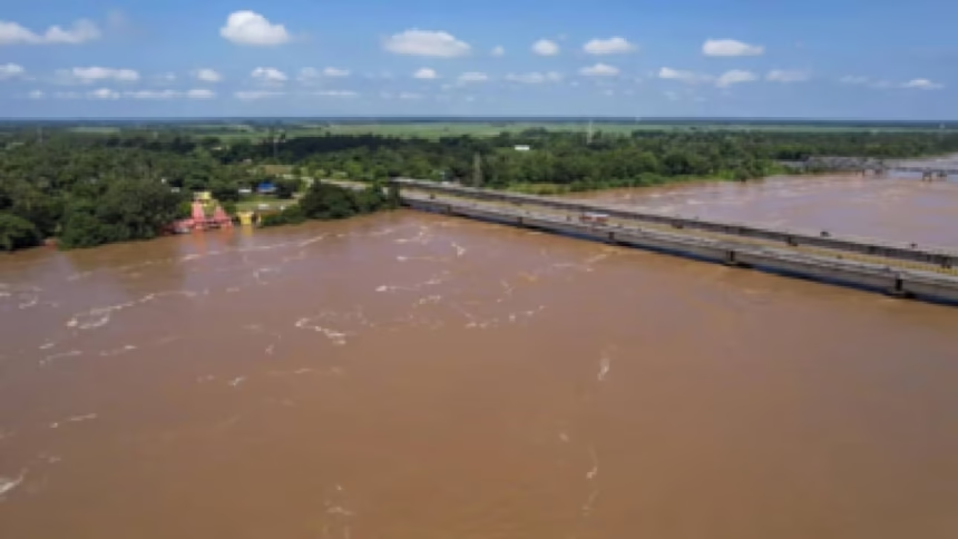
The Dhansiri River in Assam’s Golaghat district has reportedly continued to breach safety levels, leaving nearby areas in a severe flood situation. The persistent rise has increased concerns for communities, roads, agriculture, and other infrastructure located near the river.
The continuing overflow comes amid broader concerns about uneven and intense monsoon conditions across Assam. Moreover, prolonged high water levels can place additional pressure on embankments, drainage networks, bridges, and low-lying settlements.
Authorities are expected to maintain close monitoring of the river and surrounding areas. However, the available information does not provide the latest gauge reading, the number of affected residents, or details of any evacuation orders.
Assam Reviews Flood Mapping After Worst-Hit Districts
Dhansiri River Remains Above Safety Levels
The Dhansiri River has reportedly remained above its safety mark in Golaghat district.
When river levels remain elevated for an extended period, nearby low-lying areas can face increasing flood pressure. Furthermore, continued water flow can make roads and local transportation routes more difficult to use.
The situation therefore requires sustained monitoring.
However, the exact current water level has not been provided.
Golaghat Faces Continued Flood Pressure
Several areas around Golaghat can become vulnerable when the Dhansiri remains high.
Floodwaters can affect residential areas, agricultural fields, roads, and public infrastructure. Additionally, prolonged flooding can disrupt access to essential services and make movement difficult for residents.
The continued river rise therefore presents a significant local concern.
However, the available information does not establish the total geographical area currently affected.
Severe Flood Situation Raises Concerns
A severe flood situation can create multiple challenges for local communities.
Authorities may need to monitor vulnerable settlements, embankments, bridges, and important transportation routes. Moreover, prolonged flooding can increase the need for relief supplies, medical support, drinking water, and temporary shelter.
Preparedness becomes increasingly important when river levels remain high.
However, no specific relief requirements have been provided in the reported information.
Monsoon Rainfall Adds Pressure
The Dhansiri’s condition comes amid unusual rainfall patterns across Assam.
While some parts of the state have reportedly experienced rainfall deficits, isolated areas have recorded exceptionally heavy precipitation. Furthermore, intense rainfall in upstream catchments can increase river levels downstream.
This uneven rainfall distribution can make flood conditions difficult to predict.
However, the precise rainfall contribution to the latest Dhansiri rise has not been established.
Low-Lying Areas Face Greater Risk
Communities located near riverbanks and low-lying terrain can face greater exposure to rising water.
Floodwater can enter agricultural land and residential areas when river levels remain elevated. Additionally, saturated soil can reduce the landscape’s ability to absorb further rainfall.
Authorities may therefore need to maintain heightened surveillance around vulnerable locations.
However, the available information does not identify specific villages currently facing the greatest risk.
Infrastructure Could Face Stress
Prolonged high river levels can place pressure on infrastructure.
Roads, bridges, embankments, culverts, and drainage systems can experience increased water exposure. Moreover, erosion along riverbanks can weaken nearby structures and transportation routes.
Regular inspections can help identify problems before they become more serious.
However, no specific infrastructure damage has been reported in the information provided.
Agriculture Remains Vulnerable
Flooding can create significant challenges for farmers.
Standing water can damage crops, erode soil, and delay agricultural operations. Furthermore, prolonged flooding can affect livestock and access to agricultural fields.
The economic effects can continue even after floodwaters recede.
However, the extent of agricultural losses in Golaghat has not been specified.
River Monitoring Becomes Essential
Continuous monitoring can help authorities understand whether the situation is improving or worsening.
Officials can track river gauge readings, rainfall forecasts, upstream conditions, and water movement. Additionally, local field reports can provide information about flooding in communities that may not appear immediately in broader datasets.
Such monitoring supports faster decision-making.
However, the latest gauge reading is not available in the information provided.
Communities Need Timely Warnings
Clear communication can help residents respond to changing flood conditions.
Authorities can issue warnings about rising water, unsafe roads, evacuation needs, and access to relief facilities. Moreover, timely information can help families protect important documents, livestock, and essential supplies where possible.
Communication becomes particularly important when river levels change quickly.
However, the available information does not indicate whether new evacuation advisories have been issued.
Relief Operations May Need Coordination
If flooding persists, relief agencies may need to coordinate resources across affected areas.
Authorities can assess requirements for food, drinking water, medicines, sanitation facilities, and temporary shelters. Furthermore, transportation teams may need to identify safe routes for delivering essential supplies.
Coordination can help prevent shortages during prolonged emergencies.
However, no specific relief operation has been detailed in the information provided.
Embankment Safety Requires Attention
High river levels can increase pressure on flood-control structures.
Officials may inspect embankments for erosion, seepage, cracks, and other warning signs. Additionally, rapid intervention can help reduce the risk of a local breach if authorities identify structural weaknesses.
Embankment monitoring therefore remains an important part of flood management.
However, no embankment breach has been reported in the available information.
What Happens Next?
Authorities are expected to continue monitoring the Dhansiri River and flood-affected areas of Golaghat.
Officials may adjust preparedness measures according to river levels, rainfall forecasts, and conditions in nearby settlements. Moreover, relief and rescue resources can be redirected if flooding intensifies.
The situation will depend partly on rainfall in the river’s upstream catchment.
However, the available information does not provide a forecast for when the river will return below its safety level.
Conclusion
The reported Dhansiri River overflow has kept parts of Golaghat district in a severe flood situation as the river continues to remain above safety levels. Persistent high water can place pressure on communities, agriculture, roads, embankments, and other infrastructure near the river.
Moreover, Assam’s uneven monsoon pattern can complicate flood forecasting, particularly when intense rainfall occurs in specific catchment areas. Therefore, continued river monitoring, timely warnings, infrastructure inspections, and coordinated relief planning remain important.
Overall, the Dhansiri flood situation underscores the need for sustained preparedness while water levels remain elevated across vulnerable parts of Golaghat.
FAQs
1. Where is the Dhansiri River causing flood concerns?
The reported flooding is affecting areas around the Dhansiri River in Golaghat district, Assam.
2. What is the current reported condition?
The river reportedly continues to breach its safety mark, leaving the area in a severe flood situation.
3. Why can prolonged high river levels be dangerous?
They can increase risks to settlements, agriculture, roads, bridges, embankments, and other infrastructure.
4. What should authorities monitor?
Authorities can monitor river gauge levels, rainfall forecasts, upstream conditions, embankments, and vulnerable settlements.
5. Has the river’s exact water level been provided?
The information provided does not include the latest numerical gauge reading.