





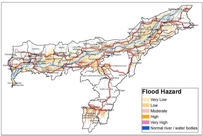
The Assam Disaster Management Authority has reportedly highlighted a major gap between historical disaster-risk classifications and the current flood situation. According to the reported assessment, the three worst-hit districts had previously carried low-risk classifications, which contributed to delays in the initial deployment of emergency forces.
The development has raised questions about how authorities use geographic information system (GIS) mapping to prepare for rapidly changing disaster conditions. Moreover, historical risk assessments may not always reflect new environmental, infrastructure, settlement, and rainfall patterns.
The reported mismatch could encourage authorities to reassess existing disaster maps and emergency deployment protocols. However, the available information does not identify the three districts or provide details about the exact GIS models used in their earlier classifications.
Meghalaya Forms Multi-Departmental Taskforce to Deliver Flags
GIS Risk Mismatches Raise Concerns
The reported assessment by the Assam Disaster Management Authority points to discrepancies between historical risk classifications and the severity of the latest flooding.
GIS-based disaster maps help authorities identify areas that may face greater exposure to floods and other hazards. Furthermore, officials can use these maps to plan resources, evacuation routes, emergency shelters, and rescue operations.
However, the latest situation reportedly showed that some areas previously considered low risk experienced severe impacts.
Low-Risk Classification Affected Deployment
The three worst-hit districts reportedly carried low-risk classifications in historical assessments.
Such classifications can influence how authorities prepare emergency resources and position response teams. Additionally, lower-risk areas may receive fewer advance deployments compared with locations that consistently appear on high-risk maps.
The reported mismatch therefore created an operational challenge.
However, the available information does not establish that the classifications alone caused the delay in emergency deployment.
Flood Patterns Can Change
Historical disaster maps rely heavily on information from previous events and established risk indicators.
Flood behaviour can change when rainfall patterns, drainage systems, river courses, land use, and settlement patterns evolve. Moreover, rapid urbanisation and changes in natural water-retention areas can alter how quickly water accumulates.
Authorities may therefore need to update risk assessments regularly.
However, the extent to which these factors contributed to the latest flooding has not been specified.
Emergency Forces Need Timely Information
Disaster response depends heavily on accurate information.
Emergency agencies need to know where flooding is most severe so they can position rescue teams, boats, medical personnel, and other resources. Furthermore, rapidly updated information can help officials redirect forces when conditions change.
GIS systems can support this process when authorities update them with current data.
However, mapping alone cannot predict every extreme weather event.
Historical Data Has Limitations
Past disaster records provide valuable information for emergency planning.
Authorities can use historical flood levels, rainfall records, river behaviour, and previous damage patterns to identify vulnerable areas. Additionally, historical data can help establish long-term trends.
Nevertheless, past patterns may not fully capture new risks.
The reported situation demonstrates why historical classifications require periodic review.
Real-Time Monitoring Becomes Important
Real-time information can complement long-term GIS mapping.
Satellite imagery, rainfall observations, river-level monitoring, weather forecasts, and field reports can provide updated information during an emergency. Moreover, combining these sources can help authorities identify rapidly developing flood threats.
Such systems can support faster resource deployment.
However, the available information does not specify which real-time tools officials used during the latest flooding.
Disaster Maps May Need Regular Updates
Risk classifications cannot remain static as environmental conditions change.
Authorities may need to update maps after major floods, infrastructure changes, river shifts, or significant land-use changes. Furthermore, new climate and rainfall data can help improve future risk assessments.
Regular updates could reduce the possibility of outdated classifications influencing emergency decisions.
However, updating disaster maps requires reliable data and technical capacity.
Impact on Rescue Planning
Risk mapping can influence how authorities prepare rescue operations.
High-risk districts may receive greater attention during preparedness exercises and emergency planning. Additionally, agencies can pre-position equipment and personnel based on expected vulnerability.
If a severely affected district carries a low-risk rating, officials may need to rely more heavily on real-time assessments.
The reported mismatch highlights this planning challenge.
Local Information Can Complement GIS
Residents and local officials often possess valuable knowledge about flood-prone locations.
They can identify roads that become inaccessible, drainage points that overflow, and settlements that experience repeated water accumulation. Moreover, local reports can provide information that may not appear in older GIS datasets.
Combining community-level knowledge with digital mapping could strengthen preparedness.
However, authorities would need systems to verify and integrate such information effectively.
Early Deployment Remains Critical
Emergency response teams can make a greater difference when they reach affected areas quickly.
Delays can complicate rescue operations, evacuation, medical assistance, and distribution of essential supplies. Furthermore, rapidly rising floodwaters can restrict access and make later deployments more difficult.
Accurate risk assessments can therefore support faster preparedness.
However, deployment decisions also depend on weather forecasts, road conditions, available personnel, and the scale of the emergency.
Assam Could Strengthen Disaster Preparedness
The reported GIS mismatch could encourage Assam to reassess its disaster-management systems.
Authorities may review district-level risk categories and compare them with recent flood damage. Additionally, officials could consider incorporating more current environmental and climate information into future assessments.
Such reviews could improve preparedness for subsequent emergencies.
However, no specific revision plan has been announced in the information provided.
Technology and Human Judgment
Digital mapping provides valuable information, but emergency decisions also require human assessment.
Officials can combine GIS data with weather warnings, field reports, local knowledge, and direct observations. Moreover, flexible decision-making can help authorities respond when actual conditions differ from historical expectations.
A combined approach can reduce reliance on any single information source.
However, the effectiveness of such systems depends on coordination and timely communication.
What Happens Next?
The reported mismatch may prompt authorities to examine how Assam currently classifies flood risks across districts.
Officials could compare historical maps with recent damage patterns and update vulnerable-area assessments where necessary. Furthermore, disaster agencies may explore stronger real-time monitoring and faster mechanisms for shifting emergency resources.
Such changes could improve future response planning.
However, the exact steps Assam will take remain unclear.
Conclusion
The reported GIS risk mismatch in Assam has highlighted a challenge in disaster preparedness after three of the worst-hit districts reportedly carried historically low-risk classifications. The discrepancy may have contributed to difficulties in determining where emergency forces should initially concentrate, although the available information does not establish a direct causal link.
Moreover, changing rainfall patterns, environmental conditions, infrastructure, and settlement growth can alter flood vulnerability over time. Therefore, authorities may need to combine updated GIS mapping with real-time weather data, field reports, and local knowledge.
Overall, the GIS risk mismatch could encourage Assam to modernise its disaster-risk assessments and strengthen systems for faster emergency deployment.
FAQs
1. What did the Assam Disaster Management Authority reportedly identify?
It reportedly identified a mismatch between historical GIS-based risk classifications and the severity of flooding in three badly affected districts.
2. How were the three districts previously classified?
The affected districts had reportedly carried low-risk classifications in historical assessments.
3. Why can GIS risk classifications affect disaster response?
Risk maps can influence emergency planning, resource positioning, preparedness exercises, and the deployment of response teams.
4. Can historical flood maps become outdated?
Yes. Changes in rainfall, drainage, land use, river behaviour, infrastructure, and settlement patterns can alter disaster vulnerability.
5. How can Assam improve future flood preparedness?
Authorities can regularly update GIS maps and combine them with real-time weather data, satellite information, field reports, and local knowledge.