






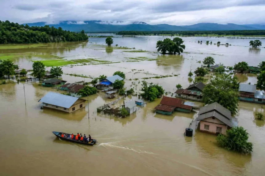
The Upstream Cloudbursts in Nagaland’s hill districts generated intense volumes of water that flowed downstream into Assam. The development highlights the interconnected nature of river systems in the Northeast and underscores the importance of continuous monitoring of rainfall, river levels, and downstream water movement during periods of heavy precipitation.
Aizawl Sinking Zone Survey Conducted
Upstream Cloudbursts Increase Water Flow into Assam
The Upstream Cloudbursts over Nagaland’s hilly regions resulted in a significant increase in water flowing downstream into Assam. According to the available information, intense rainfall events in the upper catchment areas drove large volumes of water into downstream river systems.
Cloudbursts often produce concentrated rainfall within a short period, causing rapid runoff in mountainous terrain. Moreover, rivers originating in elevated regions respond quickly to such weather events, leading to increased downstream water flow.
The latest development reflects the impact that heavy rainfall in upstream areas can have on neighboring regions. Therefore, continuous monitoring of river conditions remains essential during periods of intense precipitation.
The situation also highlights the close hydrological connection between Nagaland and Assam through shared river basins. Additionally, coordinated monitoring helps authorities assess changing water conditions more effectively.
Upstream Cloudbursts Highlight Importance of River Basin Monitoring
The Upstream Cloudbursts demonstrate why monitoring upstream weather conditions is essential for downstream water management. Heavy rainfall in hilly catchments can rapidly increase river discharge as runoff moves through interconnected waterways.
Moreover, hydrological monitoring allows authorities to observe changing river levels and assess developing conditions. Consequently, timely information supports informed decision-making regarding water resource management and disaster preparedness.
Mountainous regions naturally experience faster runoff because of their terrain and steep river gradients. Furthermore, weather monitoring plays an important role in tracking rainfall intensity and its influence on downstream rivers.
The available information confirms that cloudbursts in Nagaland increased water volumes flowing into Assam. However, no official details have been released regarding rainfall intensity, river discharge measurements, or the specific river systems affected.
Hydrological Conditions Shape the Upstream Cloudbursts Impact
The Upstream Cloudbursts illustrate how weather events in upland regions influence downstream hydrological conditions. Water generated by intense rainfall moves through river networks before reaching lower-lying areas, making continuous observation an important aspect of river management.
Additionally, hydrological agencies routinely monitor rainfall, reservoir conditions, and river flows during periods of adverse weather. This approach helps improve situational awareness and supports coordinated responses when required.
The latest update reflects natural water movement following heavy rainfall rather than any reported structural failure or reservoir release. Meanwhile, authorities continue monitoring weather and river conditions during the active monsoon period.
The available information does not indicate the extent of downstream flooding or damage resulting from the increased water flow. Therefore, the update relates specifically to the movement of higher water volumes from Nagaland into Assam.
The development reinforces the importance of integrated watershed monitoring across state boundaries.
Upstream Cloudbursts Emphasize Regional Weather Preparedness
The Upstream Cloudbursts carry broader significance for weather monitoring and regional disaster preparedness in Northeast India. Weather systems affecting mountainous regions often influence downstream communities through interconnected river networks.
Moreover, effective coordination between meteorological agencies and water resource authorities supports better preparedness during periods of intense rainfall. Improved monitoring also strengthens early assessment of changing hydrological conditions.
The movement of water across state boundaries demonstrates the importance of integrated river basin management. Similarly, continuous observation of rainfall and river behavior contributes to better planning and infrastructure management.
Managing the effects of extreme rainfall remains an important priority during the monsoon season. Consequently, the Upstream Cloudbursts highlight the need for sustained monitoring, coordinated information sharing, and effective water resource management across the region.
As weather conditions continue to evolve, future official updates are expected to provide additional information regarding rainfall patterns, river levels, and downstream impacts.
Conclusion
The Upstream Cloudbursts in Nagaland’s hills generated intense water volumes that flowed downstream into Assam, highlighting the influence of heavy rainfall in upper catchment areas on regional river systems. The development underscores the importance of continuous monitoring of weather conditions and river flows during the monsoon season.
Furthermore, coordinated hydrological observation supports informed decision-making and strengthens preparedness for changing water conditions. Monitoring upstream rainfall also plays a crucial role in understanding downstream river behavior.
Overall, the Upstream Cloudbursts demonstrate the interconnected nature of Northeast India’s river systems and the need for effective weather surveillance and river basin management. As official monitoring continues, further updates are expected to provide additional information on hydrological conditions across the region.
FAQs
1. What caused the increased water flow into Assam?
The Upstream Cloudbursts in Nagaland’s hills produced heavy rainfall, resulting in intense volumes of water flowing downstream into Assam.
2. What are cloudbursts?
Cloudbursts are highly concentrated and intense rainfall events that occur over a short period and can generate rapid surface runoff.
3. Why do upstream weather events affect Assam?
Rivers flowing from Nagaland into Assam carry water from upper catchment areas, making downstream regions sensitive to heavy rainfall upstream.
4. Did the update mention any reservoir gate releases?
No. The available information only states that cloudbursts increased water volumes flowing downstream and does not mention reservoir releases.
5. Why is river monitoring important during cloudbursts?
River monitoring helps authorities track changing water levels, assess hydrological conditions, and support preparedness during periods of intense rainfall.